When Every Mile Was a Mystery: The Lost Art of Navigating America Without a Clue
Picture this: You're planning a family vacation from Chicago to the Grand Canyon in 1985. Your preparation ritual begins three months early with a trip to the local AAA office, where you sit across from an agent who hand-draws your route on a series of connected maps called a TripTik. You walk out with a flip-book of directions, a stack of motel guides, and the quiet understanding that you're about to spend two weeks navigating America with roughly the same tools Lewis and Clark used.
This was road trip planning in the pre-digital age — a elaborate dance of preparation, guesswork, and faith that somehow got millions of Americans safely to their destinations every summer.
The Paper Trail to Adventure
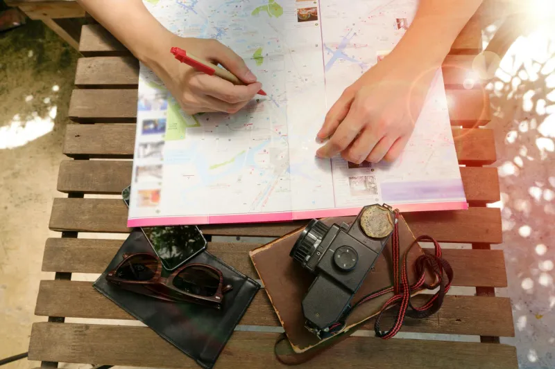
Before smartphones made every intersection predictable, planning a cross-country drive meant collecting physical evidence of your intended route. The centerpiece was the AAA TripTik, a personalized flip-book of maps that traced your exact path across state lines. AAA agents would sit with you for twenty minutes, marking construction zones, suggesting scenic detours, and circling recommended gas stations with a red pen.
But the TripTik was just the beginning. Serious road trippers accumulated guidebooks like "Mobil Travel Guide" and "Duncan Hines' Adventures in Good Eating," thick paperbacks that rated every motel and restaurant between your driveway and your destination. These books became worn soft at the corners, stuffed with handwritten notes and phone numbers scrawled in margins.
Families would spend entire evenings at the kitchen table, plotting their route with rulers and highlighters. Dad would trace the interstate highways while Mom called ahead to make reservations at motor lodges, often booking rooms she'd never seen based solely on a two-line description in a guidebook.
When Getting Lost Was Part of Getting There
Without real-time traffic updates or GPS recalculation, every wrong turn became a genuine adventure. Missing an exit didn't mean your phone would chirp "recalculating" and guide you back on track in three minutes. It meant pulling into a gas station, unfolding a map across your hood, and asking the attendant for directions that usually began with "Well, you can't get there from here, but..."
These impromptu navigation sessions often led to unexpected discoveries. The scenic route through small-town America wasn't something you selected from a menu of options — it was what happened when you missed the interstate entrance and had to wind through back roads for fifty miles before finding your way back to the main highway.
Families developed elaborate systems for staying found. Some parents appointed the oldest child as "navigator," teaching them to read maps and watch for highway markers. Others relied on CB radios to chat with truckers who knew every shortcut and speed trap between coast to coast.
The Payphone Lifeline
When something went wrong — and something always went wrong — your lifeline was a payphone outside a gas station or truck stop. Calling ahead to confirm motel reservations meant pulling over every few hours, feeding quarters into a phone booth, and hoping the desk clerk at the Desert Palms Motor Lodge actually remembered taking your reservation three weeks earlier.
Breakdowns meant walking to the nearest phone, calling information for a local garage, and explaining your location using landmark descriptions like "about five miles past the big water tower" or "near the billboard with the cowboy hat."
The Mental Load of Movement
What's remarkable about pre-GPS travel isn't just that it was less convenient — it's how much mental energy Americans devoted to simply getting from place to place. Every family road trip required genuine navigation skills, spatial reasoning, and the ability to read paper maps while bouncing down the interstate at 65 mph.
Parents became amateur geographers, teaching their children to understand scale, direction, and the relationship between the squiggly lines on paper and the actual landscape rolling past their windows. Kids learned to navigate by reading highway signs, counting mile markers, and recognizing the distinctive shapes of different states.
From Adventure to Algorithm
Today's road trips unfold with algorithmic precision. Your phone knows exactly where you are, where you're going, and how long it will take to get there. It warns you about traffic jams before you encounter them, suggests gas stations when your tank runs low, and automatically finds alternate routes when construction blocks your path.
What we've gained in efficiency, we've lost in serendipity. Modern travelers rarely discover hidden gems by accident, stumble across roadside attractions they never intended to visit, or meet locals who redirect their entire itinerary with a casual recommendation.
The Quiet Revolution
The transformation happened so gradually that most Americans barely noticed. First came MapQuest printouts in the late 1990s, replacing hand-drawn directions with computer-generated turn-by-turn instructions. Then GPS units appeared on dashboards, speaking directions in robotic voices. Finally, smartphones made navigation so seamless that getting lost became almost impossible.
Each technological step eliminated a layer of uncertainty, planning, and human interaction that had defined American travel for generations. The result is undeniably more efficient — but it's also fundamentally different. We've traded the adventure of not knowing exactly where we're going for the comfort of always knowing exactly where we are.
The next time your phone automatically guides you around a traffic jam or suggests a faster route, remember that just thirty years ago, every American family vacation was essentially an expedition into the unknown, armed with nothing but paper maps, handwritten directions, and the quiet confidence that somehow, they'd figure it out along the way.