Unfolding the Map: What Finding Your Way Used to Actually Cost You
Unfolding the Map: What Finding Your Way Used to Actually Cost You
There's a particular kind of anxiety that younger drivers have probably never experienced. It goes something like this: you're somewhere in an unfamiliar city, it's getting dark, your handwritten directions say "turn left at the Kmart" but you haven't seen a Kmart, and the person in the passenger seat is holding a paper map upside down and insisting you already missed the exit.
For most of the twentieth century, that was just driving somewhere new.
The Preparation That Happened Before You Left the Driveway
Planning a road trip in, say, 1974 was a project that started days before departure. Serious travelers would write to AAA — the American Automobile Association — and request a "TripTik," a custom-made spiral-bound booklet of maps tracing your specific route, hand-annotated with construction zones and points of interest. It usually arrived by mail. You planned accordingly.
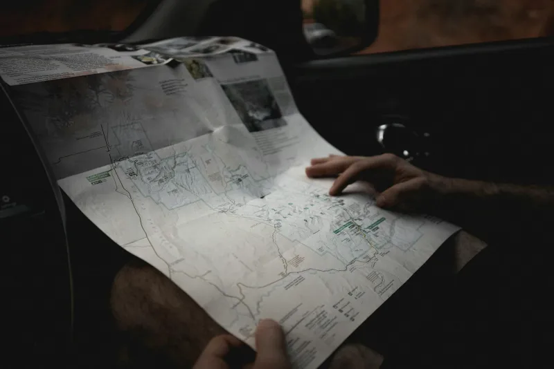
For shorter or more spontaneous trips, the gas station map was the resource of choice. Oil companies produced them by the hundreds of millions — Rand McNally printed maps for Mobil, Esso, and Gulf — and they were handed out free at the pump as a customer service gesture and a branding exercise. At peak distribution in the late 1960s, American oil companies were giving away an estimated 200 million road maps per year.
Those maps were carefully made, surprisingly detailed, and genuinely useful. They were also, famously, nearly impossible to refold correctly once opened. Every American family of a certain age has a glove compartment memory involving a map that had been accordion-collapsed into something resembling a failed origami project.
Asking Strangers Was a Survival Skill
Even with a good map, gaps happened. Street names didn't always match. Rural roads weren't always marked. Cities changed faster than print runs could keep up with. So drivers asked people.
Stopping to ask for directions was a completely normal part of driving somewhere unfamiliar. Gas station attendants were considered reliable sources — they saw hundreds of cars a day and knew local roads well. Locals on sidewalks were regularly flagged down. Hardware store owners, diner waitresses, farmers at the end of a driveway — everyone was a potential navigation resource.
This required a certain social confidence that GPS has quietly made optional. You had to be willing to admit you were lost, explain where you were trying to go, interpret the directions you received (often delivered in landmarks rather than street names — "turn left where the old Miller barn used to be"), and then execute. It was a genuine interpersonal transaction.
And the directions weren't always right. People misremember distances. They forget to mention the confusing fork. "You can't miss it" has probably been said about thousands of places that were, in fact, very easy to miss.
The Mental Load of Getting There
What's striking, looking back, is how much active cognitive work navigation demanded. Drivers had to hold a mental model of their route, track progress against landmarks, make judgment calls at ambiguous intersections, and recalibrate when things went wrong — all while driving. The passenger's job was often specifically to manage the map and call turns in advance.
This wasn't seen as a burden at the time. It was just what driving somewhere new required. You developed a feel for cardinal directions, a habit of noting landmarks, and a rough internal odometer. Many experienced drivers could estimate mileage traveled with surprising accuracy just from feel and time.
That spatial awareness was a real skill, built through repetition. Researchers have since documented that heavy reliance on GPS navigation is associated with reduced activity in the hippocampus — the part of the brain responsible for spatial memory. London taxi drivers, famously required to memorize the city's streets before licensing, show measurably enlarged hippocampal regions. Navigation, it turns out, is exercise for the brain. And we've largely stopped doing it.
GPS Changed Everything, Almost Instantly
The transition happened faster than most technology shifts. Dedicated GPS units from Garmin and TomTom became mainstream consumer products around 2005 and 2006. Within a few years, smartphones with Google Maps had made even those devices feel redundant. By the early 2010s, the paper map had moved from glove compartment staple to curiosity.
Rand McNally, which had printed road atlases for over a century, watched its map sales collapse. Gas stations stopped stocking them as a matter of course. The free oil company map — once a fixture of American road culture — had already been gone for decades.
What replaced all of it was a system of almost supernatural accuracy. Turn-by-turn audio directions. Real-time traffic rerouting. Arrival time estimates that account for current congestion. Street-level photography of your destination. The contrast with a folded paper map and a stranger's directions is almost incomprehensible.
Then, This, Now
GPS navigation is, without serious argument, better. It's faster, more accurate, less stressful, and has probably prevented millions of arguments in cars across America.
But something quiet happened in the exchange. Getting lost used to be an adventure with a story at the end of it. Asking for directions used to connect you, briefly, to the place you were passing through. Reading a map used to make you an active participant in your own journey rather than a passenger following instructions.
None of that is worth going back to. But it's worth knowing it existed — and maybe noticing what we stopped practicing when we handed the thinking over to the phone.